It is the end of Summer, and about the time of year that I usually take my vacation time, to somewhat coordinate with the start of hawking season, trapping and training, and getting old hawks back on the wing after the molt. I had asked for some time off to give me a week window and planned to go visit Door County again, but my house-sitter was on a slightly more constrained schedule and needed us to be back sooner than I wanted to try to get to northeast Wisconsin and back. I set my sights on a somewhat closer destination, and looking at the map, got a rather hair-brained idea. Why not tour our home state, and see some things we've not seen. In fact, why not make an effort to touch the four corners, and some in-between points. I had three days to start the project. Next month I have a block of two weeks to finish it up.

The first point was rather easy, as it is about a 20 minute drive from Rich's family's farm. They live in Spring Grove, which is already far southeast Minnesota. On a sunny Sunday (9/17/17) I drove the additional miles and took my picture at the border. Now, to be absolutely honest, if I was to be on the actual geographic border of the state it would require I walk (swim) an additional half mile or so East, into a marsh and then river. The actual border is in the middle of the Mississippi River. I'm going to go with "close enough" and just hit points that are reachable by road.

September 17, 2017 5:45 PM
43°30'3"N, 91°17'5"W
Elevation 620 ft

Rich joined me for the three-day road trip. I didn't have a whole lot of planning for this trip, and pretty much threw caution to the wind and was spontaneous with our itinerary. Once we finally got ourselves out on the road on Monday, our first destination was Albert Lee. This is the gateway into Minnesota if you are taking I35. Following the map, and getting off the interstate, I found a back road, and sure enough, there was a road called State Line.

September 18, 2017 2:50 PM
43°29'57"N, 93°21'32"W
Elevation 1240 Ft
We found our way back to the interstate and I took this video crossing the state line.
We continued our journey on Monday, stopping in Worthington for some supplies that I didn't pack. I really hadn't planned well for this trip. We also picked up some steaks to grill for our dinner. Our final destination for the night was Blue Mound State Park. It's the farthest southwest park you can go to in the state. The night was perfect, the temperature in the comfortable low 70s, with minimal bugs. It was a very enjoyable evening, reminding me of all the nice camping Rich and I did when we were dating and first married.
We were up early and back on the road by 8 am. I had wanted to take a picture of the prime feature of Blue Mound State Park . . . their claim to fame of the largest pure herd of American Bison. They have access to a large prairie enclosure, which would have made for a picturesque image. However, all the bison were gathered near their feed bunk, and just looked, and were acting, like a bunch of cattle. No pictures were taken!
Our first destination of the morning was the far Southwest corner. In fact, I think this is the corner that gave me the idea to circle the state. While looking at Google Maps, I was zooming in on this corner, and discovered the Tri-State Iron Post Historical Marker at this location. This is the corner of Minnesota, Iowa, and South Dakota. It was windy and a bit foggy and chilly, so we didn't stay out long. Hey, it even has a facebook page!


September 19, 2017 9:00 AM
43°30'3"N, 96°27'12"W
Elevation 1460 Ft.

After visiting the Tri-State border, we drove North to visit Pipestone National Monument. I had heard about this park before and was interested to visit. If you want a more thorough history, you can go here. It is one of the best known location of catlinite, or pipestone, which is a soft, reddish stone that can withstand heat when used as a pipe, but is soft enough to carve. The smoking of a ceremonial pipe is very important to Native American culture, and the site is considered to be sacred, as are the pipes that are produced from the stone quarried there. Only Native Americans with affiliation to recognized tribes are given the permits to dig for the stone. I did discover that you can purchase products from the stone. At the monument, we viewed the video and looked at the museum pieces, and watched and talked with a woman who was demonstrating the art of carving pipestone.

We walked around the nature trail. The site really is beautiful, made even more so by the fall colors. Go full screen on this video below to fully appreciate it.

The woman who was demonstrating carving this day is Alice. She is a member of the Dakota Sioux. His son has an active quarry on site. She was carving turtles. As she worked we talked about turtles and toads.

After our walk, we returned to the information center and I was chatting with the Ranger, then looking up was wondering where Richard had gone. I found him in the gift shop. He had observed my fascination with a certain design of pipe, eagle heads, which could just as easily be hawk heads. He surprised me by purchasing one for me. I then bought some herbal tobacco, and would go on once we got home to share the experience with my house-sitter (a long-time friend of mine), and some close friends of ours who we visit often over food and a movie. The smoking of a pipe has significant ceremonial importance to Native American culture. I do not share their heritage, but I can respect the practice. Producing smoke is seen as an outward manifestation of prayer to the Great Spirit, or God. When I shared the practice with my friends, I am thankful for the birds I get to work with, the animals we can hunt together, and the friends that join me in this activity.

After our visit to Pipestone, we got on the road and took the long hike up North, to our furthest destination on this trip, the joint cities of Fargo-Moorehead. I finally found a bison I could take a picture with.

At the information center I located they even had the famous (infamous) wood chipper that was used in the 1996 movie Fargo. It is a well-known tourist attraction for the city. We had dinner in the city, and then visited a museum dedicated to the Hjemkomst. We got lucky, and it was "stay open late and no entrance fee" night. I'm not a big boat fan, but Richard finds them interesting. We saw the original that inspired the construction of the Hjemkomst when we visited in Norway and saw the Gokstad ship at the museum district of Bygdoy. I was surprised and intrigued to learn about the story of this Norwegian-inspired ship and the story of the people who built and sailed her. There is a old documentary shown at the museum to explain the ship and tell the tale, and sure enough, I found it on YouTube.
Here is a quick view to give perspective of the size. Yes, the ship is entirely enclosed in the building.
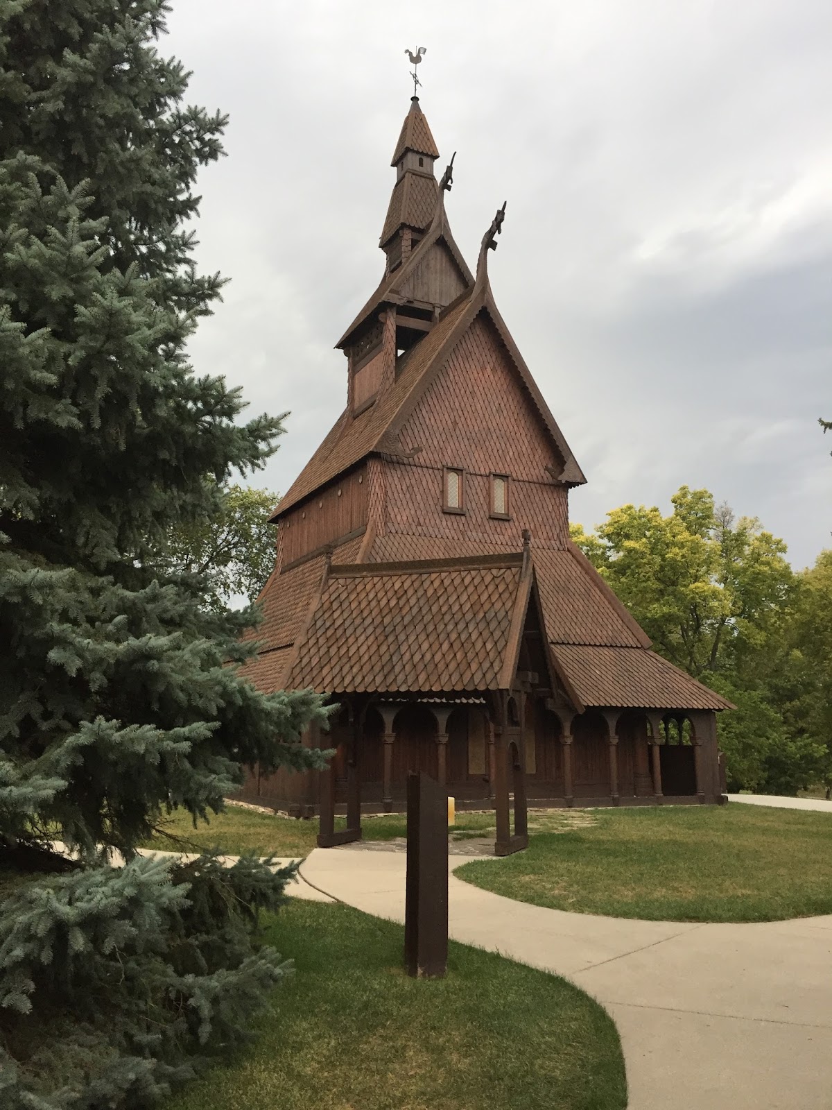
On a similar theme, behind the museum, a different person was inspired by the stave churches of Norway and decided to recreate one here in America. This building is made entirely of wood, with many fine carvings. We got the opportunity to see the inside and get a tour. We also saw several of these while in Norway. The link above to my blog post has pictures of some of them.
Inside the church, while on tour, our guide had some historical recreations of weaponry, which I had to have my Norwegian-descent husband try on.

In the lobby, before we left, he posed with some of the locals.

It was a very quick visit to Fargo-Moorhead, and perhaps we will visit again next month when we set out to finish this project. They had a very nice bridge that would make the perfect location for my pictures and GPS coordinates, however . . . IT WAS RAINING! Not just raining, but there was a lightning show too. This put the kibosh on my plan to camp another night. It was just too windy, wet and frankly dangerous. Documenting our being on this in-between place in Minnesota would be a video crossing the Red River which transects the two cities.

September 19, 2017 I don't know, sometime after 8 PM
GPS - I don't know . . . it was raining!
Elevation . . . no clue . . . it was raining!

After crossing the bridge, we made our way to Alexandria and found a hotel for the night. The next morning we acquainted ourselves with Big Ole, a tourist attraction just outside the Kensington Runestone Museum. This is an artifact that was unearthed in 1898, which if authentic, would lend proof that Norsemen made it far into the new world long before Columbus did. The validity of the claim is disputed. After you visit the museum, you can make up your own mind about it.

With museum visiting and giant viking watching done, we left Alexandria in search of an apple orchard. On the way, I spotted this rather beautiful red tail catching some morning rays. It is an adult with it's rusty red tail, so not trappable, even if I had my trapping gear with me. In the morning light, the rest of its body was rather washed out light. It would have been nice to see this bird in hand. Red tails have such a variety of color, even among standard eastern type. Soon I will be trapping for this season . . . the cooling fall weather and colors lends excitement to that prospect.

We found the orchard and purchased a lot of apple-based products to take home.

We briefly thought about trying to find the geographic center of the state, however the exact coordinate was disputed by various web sites, I did not have a GPS tracker on me, and some of those coordinates placed the point somewhere in the middle of a lake. We gave up on that plan and decided to make our way home. Along the way, we stopped in at New Ulm, where many people of German ancestry settled. Here they erected a statue at what has become known as the Hermann Heights Monument. The residents just call him Hermann the German.

Of course, once the Germans got settled in, they had to start making beer. While in that town Richard wanted to visit the Schell Brewery. At this time of year, tours are only offered on the weekends, so we could not actually see the beer being made. We were able to visit their museum and gift shop. I don't know why I didn't take my own pictures. The one below is stolen off the Internet. We were in this room, and saw some of the surrounding grounds, which are very beautiful. This was the former home of the family that established this brewery. After purchasing a few souvenirs, and with suggestion from one of the staff, we returned back into New Ulm and found a bar that serves Schell's brews on tap. I bought Rich a flight of beers, which he enjoyed. Afterwards, we sought out a German restaurant and had dinner before heading home.

It was a quick whirlwind road trip of three days. I have some more time next month when we will pick up and add onto this trip.
Until then . . . . . . .

