Friday, October 27, 2017

Touching the Four Corners (and a few in-between points) - Part II

With the arrival of October, and getting through the first week when I had to work, my end-of-summer vacation began.  We would pick up the project of circumnavigating our home state of Minnesota and touch the Four Corners, and a few points in-between.
October 12, 2017
Fargo-Moorhead
46°52'25" N, 96°46'33" W
Elevation:  910 feet

We would start off this project where we left off, and get that bridge picture in Fargo-Moorhead.  We had camped the previous night at the nearby Buffalo River State Park.  There were only two other people in the camp ground that night, and they were both in travel trailers.  The weather was still good enough for hardy folks to sleep in a tent.  The weather would hold for us, mostly, through our whole trip, with many cool but sunny days, with spectacular fall colors.  Once settled into our camp ground, we ventured out to a small nearby town for some quick dinner before they closed.  Our night was star-filled, and beautiful!


The next morning we were up early and on the quest for both bagels, and a bridge.  During our previous visit we missed both due to the store being closed (for the bagels) and rain (for the bridge).  We found the bagels and were at their door when they opened.  Those secured, we found the bridge, where we ate them for our breakfast, then took a brisk walk from the parking lot up to the bridge.  This is one of the major crossing points between Fargo, North Dakota and Moorhead, Minnesota.


There is a joint memorial for the armed forces of each state.  The view below was the Minnesota side.


Between, inlaid with the concrete, is a map of the river as it flows between the two cities.


Here is the view of the North Dakota side.


Our bagel run scored me one of the "famous" (so they say) rainbow bagels from Boppa's Bagels.


It tasted just like any other regular bagel, but was very colorful.  There was even a ribbon of purple which did not show in this picture below.


After pictures on the bridge we made our way back to the car and got out onto the road, headed North.  I did observe that some of the crops in the fields were not crops I was familiar with.  In many places I also noticed these odd objects on the road.  Rich knew what they were.  I had him pull over, and I grabbed one.  I did post it to Facebook, asking who among my friends could identify it first.  It turns out to be a sugar beet, which according to Wikipedia is actually one word, "sugarbeet".  Yes, I did taste it, a clean slice from the inside.  It tastes like beets, only much sweeter than the regular red ones.  Rich commented: "We'll probably soon see a pile of them, because that is how they store them after harvest."


Sure enough, he was right!  We would go on to see many piles of sugarbeets all along our journey along the upper Northwest of Minnesota.  We also passed the Crystal Sugar processing plant in East Grand Forks.


Our next destination was Noyes, Minnesota.  This small town may have seen more active days when it was the border crossing into Canada, but now this location is closed down on both sides.
October 12, 2017
Noyes, MN, Northwest Corner
48°59'53" N, 97°12'30" W
Elevation:  812 feet


We both posed at the boundary monument.


According to the Wikipedia entry (see link above), this port of entry has been closed since 2003 on the Canadian side, and 2006 on the US side.  To access Canada now you must go over to Interstate 29 in North Dakota.

The old crossing is barricaded.  The road has weeds growing up in between the cracks.  The entire area has a decayed, disused vibe about it . . . but don't be fooled.  There are surveillance cameras watching on both sides.


After Noyes, we turned East, as best we could, taking a path that would lead us up to as close as we could get to the farthest Northern part of the state.  There is a small bit of land, Minnesota territory, which is called "The Angle".  However, to access it you must either have a boat to cross Lake of the Woods, or go through Canada.  We would do neither.  Instead we would get as close as we could to each side of the lake.
October 12, 2017
Below the Angle, Left of Lake of the Woods
48°59'18" N, 95°20'36" W
Elevation:  1060 Feet


As we were driving East I was delightfully surprised to spot some of these birds, as pictured above.  They are black-billed magpies.  We don't have magpies in the Eastern US.  Looking up the data on them in e-Bird I discovered that they do come into Minnesota's northern range in the winter.  Well, here they were.  Rich tried to get a good picture of them, but they were fairly wary and would not allow for close approach.  He did the best he could, and did at least get proof of their presence.


Taking back gravel roads we got to this farthest point, bordering on State Wildlife land. Somewhere beyond the line of trees is the lake.


From time to time we would spot another magpie.  This one was poking around in the gravel of the road.  It flew off as we got closer.


We drove around the connecting roads to the farthest East side of Lake of the Woods.
October 12, 2017
Below the Angle, Right of Lake of the Woods
48°50'36" N, 94°41'45" W
Elevation:  1060 Feet


What we discovered was a marina.


Pictures taken, GPS coordinates recorded, we made our way as quickly as we could to International Falls, where we found an over-priced place to sleep.

October 13, 2017
International Falls
43°36'9" N, 93°24'8" W
Elevation:  1130 Feet


The next morning, filled with fairly good hotel breakfast, we found the border crossing at International Falls.


My, but those Welcome signs are very BIG!


It is pretty much impossible to follow along the North Central to North-East corner of Minnesota without a boat.  This area is the location of Voyageurs National Park, the Boundary Waters Canoe Area Wilderness and Superior National Forest.  Not having a boat of canoe, we charted our path down South to Ely, to visit the International Wolf Center.


The facility houses educational information about North American Wolves, as well as two captive wolf packs.  The pack you can see is the ambassador display pack.  There is also a retired pack, where the animals no longer have windows and people peeking in on what they are up to.  Web cams watch all the time, both groups.  If you follow the link above you too can peek in on what the wolves are up to.


The pair of wolves above are Axel and Grayson, brothers who are the most recent addition to the exhibit pack.  They are Arctic Gray Wolves who joined the pack in 2016.


This handsome fellow above is Boltz, a Great Plains Gray Wolf, who has been at the Center since 2012.


Axel and Grayson seem to be naturals at striking stunning poses.


The whole display pack lined up along the fence, checking out what was going on with one of the caretakers on the other side.  The staff informed us that the pack is fed once a week, on Saturday, with whole deer and beavers.  We were visiting on Friday, so supper would be served the next day.  Everyone was hungry and waiting for their take-out to arrive.


There was a nice bulletin board of the current pack, both on display and retirement.


October 13, 2017
Grand Portage
47°59'59" N, 89°35'33" W
Elevation:  660 Feet


After the Wolf Center we made our way down to the North Shore, then up to the tip as far as we could drive.  Prior to our visit of the Wolf Center we did detour to Virginia and Eveleth to pass over the tallest, and one of the newest, bridges in Minnesota.  This is a new path over the Iron Range, to allow the mining company to dig out the ore under the previous route.  We could not find any place to pull over to get a picture of the bridge, so there will be no photos are videos.

I did get a video of the far Northeast tip of Minnesota.  Prior to arriving at the tip, we stopped in Grand Marais, and visited the Dockside Fish Market.  We had lunch and took a nice side of smoked fish for later.  Before going up to the tip, we located our camp site and got our tent all set up.  This night we would sleep in Judge C.R. Magney State Park.  Almost as soon as we arrived, we were waylaid by a resident chipmunk, a very brave and resourceful chipmunk, who proceeded to help himself to some corn that had spilled from the back of my car.  I had brought all of my hawk trapping gear just in case, and had food for my bait rats.  Mr. Chippy stored a great amount of corn, and we gave him a few other things to add to his larder.  A piece of banana that I offered was eaten immediately.


The view of the tip of Minnesota.


At the end of the road, before crossing into Canada, and as the sun was going down I posed at this gateway to our State.  This was the final true corner.


Having accomplished my goal, and it getting dark, but we were not quite ready to go back to our tent home and sleep, I confirmed with my cell phone resources that the probability of Northern Lights was high this night.  However, we would need to find a vantage point beyond the ridge that follows all along the North shore.  We ended up going up a portion of the Gun Flint Trail and found a little airstrip that offered us a view of the Northern horizon.  The sky did lighten at the horizon, and there were occasional fiery bands that rose up into the sky, but it never quite took off like the gif below, which was too bad.  Still, it was neat to see this most Northern of experiences.


The next morning, our tent and camping gear stored, and Mr. Chippy shooed out of my car, we explored one of the major attractions of Judge C.R. Magney State Park.  We hiked over and then along the Brule River inland until we came to the Devil's Kettle.


Rich looking back as I stopped to adjust my socks.


Part of the journey included this staircase, with 177 steps.  Yes, I counted them!  It was easy going down . . . a little more work coming back up.


The Devil's Kettle is a split in the Brule river, with half of the water apparently disappearing down a hole which has fueled much speculation on where the water comes out. This article indicates a hydrologist studied the problem earlier this year and has concluded the water reemerges a short distance from these falls.  I'll have to listen for confirmation of his test experiment, which I assume will be later this winter, when the water does not flow as quickly.


It is a very beautiful waterfall!


Rich decided to ham up my picture of him.  Such a rock star!


After our adventures with the Brule River and the Devil's Kettle, we searched out some breakfast, and then made our way down the North Shore to Hawk Harbor.  This is Frank Taylor's home away from home during hawk migration and trapping season.  He has been manning a station there for a very long time.  Rich was not with me last year when I came, but joined me this year.  The Minnesota Falconers had their meeting, and then enjoyed a cook out and company.  Many of us camped the night, which was rainy and cold. The next day Rich and I would join Frank at his trapping blind, but the weather was wet and the winds were out of the wrong direction.  We saw a few birds fly over, but none made a go at the nets. By noon we decided to head on down the road as we needed to get home by the end of the day.


While there we were able to see the club President's newest bird, an arctic tundra peregrine falcon.  He has named her Scarlet.


Our final stop and compass point reference was at Duluth, at the far tip of Lake Superior.  There are a couple crossings into Wisconsin as you go South, but these are crossings we go over frequently, to especially include the one at La Crosse, so I did not include them on this journey.
October 15, 2017
Duluth Harbor
46°45'29" N, 92°9'51" W
Elevation:  1060 Feet


Coming into town I did some quick research and found a place that makes very tasty and hearty sandwiches.  We found it, bought our lunch, then sought out a high point and a park to eat and overlook the harbor.  It was a very nice afternoon finish to a great little vacation.  I would keep my eyes open on the way home for trapping opportunities but few presented themselves, and we were rather eager to get back home.

Minnesota is a Great State to visit, from all four corners and every point in-between!


Wednesday, October 25, 2017

Trapping with the GoPro II

Here is another trapping video.  This bird had a really interesting tail, but was not a keeper due to his small size.


Sunday, October 1, 2017

Trapping with the GoPro

I've watched several videos on YouTube of hawk trapping.  This year, I hope to capture some of my own.  Here is the first one.  I'll need to adjust the camera down to get more trap and less sky.

This bird was not a keeper as he was a small-ish male.  The migration has not truly started yet, but should get going soon, hopefully in the next few weeks, as I have vacation time.  I hope to trap a new, female hunting partner as the river of birds from up north start flowing through.


Sunday, September 24, 2017

Touching the Four Corners (and a few in-between points) - Part I

It is the end of Summer, and about the time of year that I usually take my vacation time, to somewhat coordinate with the start of hawking season, trapping and training, and getting old hawks back on the wing after the molt.  I had asked for some time off to give me a week window and planned to go visit Door County again, but my house-sitter was on a slightly more constrained schedule and needed us to be back sooner than I wanted to try to get to northeast Wisconsin and back. I set my sights on a somewhat closer destination, and looking at the map, got a rather hair-brained idea.  Why not tour our home state, and see some things we've not seen.  In fact, why not make an effort to touch the four corners, and some in-between points.  I had three days to start the project.  Next month I have a block of two weeks to finish it up.


The first point was rather easy, as it is about a 20 minute drive from Rich's family's farm.  They live in Spring Grove, which is already far southeast Minnesota.  On a sunny Sunday (9/17/17) I drove the additional miles and took my picture at the border.  Now, to be absolutely honest, if I was to be on the actual geographic border of the state it would require I walk (swim) an additional half mile or so East, into a marsh and then river.  The actual border is in the middle of the Mississippi River.  I'm going to go with "close enough" and just hit points that are reachable by road.
September 17, 2017    5:45 PM
43°30'3"N, 91°17'5"W
Elevation 620 ft


Rich joined me for the three-day road trip.  I didn't have a whole lot of planning for this trip, and pretty much threw caution to the wind and was spontaneous with our itinerary.  Once we finally got ourselves out on the road on Monday, our first destination was Albert Lee.  This is the gateway into Minnesota if you are taking I35.  Following the map, and getting off the interstate, I found a back road, and sure enough, there was a road called State Line.
September 18, 2017    2:50 PM
43°29'57"N, 93°21'32"W
Elevation 1240 Ft

We found our way back to the interstate and I took this video crossing the state line.


We continued our journey on Monday, stopping in Worthington for some supplies that I didn't pack.  I really hadn't planned well for this trip.  We also picked up some steaks to grill for our dinner.  Our final destination for the night was Blue Mound State Park.  It's the farthest southwest park you can go to in the state.  The night was perfect, the temperature in the comfortable low 70s, with minimal bugs.  It was a very enjoyable evening, reminding me of all the nice camping Rich and I did when we were dating and first married.

We were up early and back on the road by 8 am.  I had wanted to take a picture of the prime feature of Blue Mound State Park . . . their claim to fame of the largest pure herd of American Bison.  They have access to a large prairie enclosure, which would have made for a picturesque image.  However, all the bison were gathered near their feed bunk, and just looked, and were acting, like a bunch of cattle.  No pictures were taken!

Our first destination of the morning was the far Southwest corner.  In fact, I think this is the corner that gave me the idea to circle the state.  While looking at Google Maps, I was zooming in on this corner, and discovered the Tri-State Iron Post Historical Marker at this location.  This is the corner of Minnesota, Iowa, and South Dakota.  It was windy and a bit foggy and chilly, so we didn't stay out long.  Hey, it even has a facebook page!


September 19, 2017    9:00 AM
43°30'3"N, 96°27'12"W
Elevation 1460 Ft.


After visiting the Tri-State border, we drove North to visit Pipestone National Monument.  I had heard about this park before and was interested to visit.  If you want a more thorough history, you can go here.  It is one of the best known location of catlinite, or pipestone, which is a soft, reddish stone that can withstand heat when used as a pipe, but is soft enough to carve.  The smoking of a ceremonial pipe is very important to Native American culture, and the site is considered to be sacred, as are the pipes that are produced from the stone quarried there.  Only Native Americans with affiliation to recognized tribes are given the permits to dig for the stone.  I did discover that you can purchase products from the stone.  At the monument, we viewed the video and looked at the museum pieces, and watched and talked with a woman who was demonstrating the art of carving pipestone.


We walked around the nature trail.  The site really is beautiful, made even more so by the fall colors.  Go full screen on this video below to fully appreciate it.


The woman who was demonstrating carving this day is Alice.  She is a member of the Dakota Sioux.  His son has an active quarry on site.  She was carving turtles.  As she worked we talked about turtles and toads.

After our walk, we returned to the information center and I was chatting with the Ranger, then looking up was wondering where Richard had gone.  I found him in the gift shop.  He had observed my fascination with a certain design of pipe, eagle heads, which could just as easily be hawk heads.  He surprised me by purchasing one for me.  I then bought some herbal tobacco, and would go on once we got home to share the experience with my house-sitter (a long-time friend of mine), and some close friends of ours who we visit often over food and a movie.  The smoking of a pipe has significant ceremonial importance to Native American culture.  I do not share their heritage, but I can respect the practice.  Producing smoke is seen as an outward manifestation of prayer to the Great Spirit, or God.  When I shared the practice with my friends, I am thankful for the birds I get to work with, the animals we can hunt together, and the friends that join me in this activity.


After our visit to Pipestone, we got on the road and took the long hike up North, to our furthest destination on this trip, the joint cities of Fargo-Moorehead.  I finally found a bison I could take a picture with.

At the information center I located they even had the famous (infamous) wood chipper that was used in the 1996 movie Fargo.  It is a well-known tourist attraction for the city.  We had dinner in the city, and then visited a museum dedicated to the Hjemkomst.  We got lucky, and it was "stay open late and no entrance fee" night.  I'm not a big boat fan, but Richard finds them interesting.  We saw the original that inspired the construction of the Hjemkomst when we visited in Norway and saw the Gokstad ship at the museum district of Bygdoy.  I was surprised and intrigued to learn about the story of this Norwegian-inspired ship and the story of the people who built and sailed her.  There is a old documentary shown at the museum to explain the ship and tell the tale, and sure enough, I found it on YouTube.


Here is a quick view to give perspective of the size.  Yes, the ship is entirely enclosed in the building.


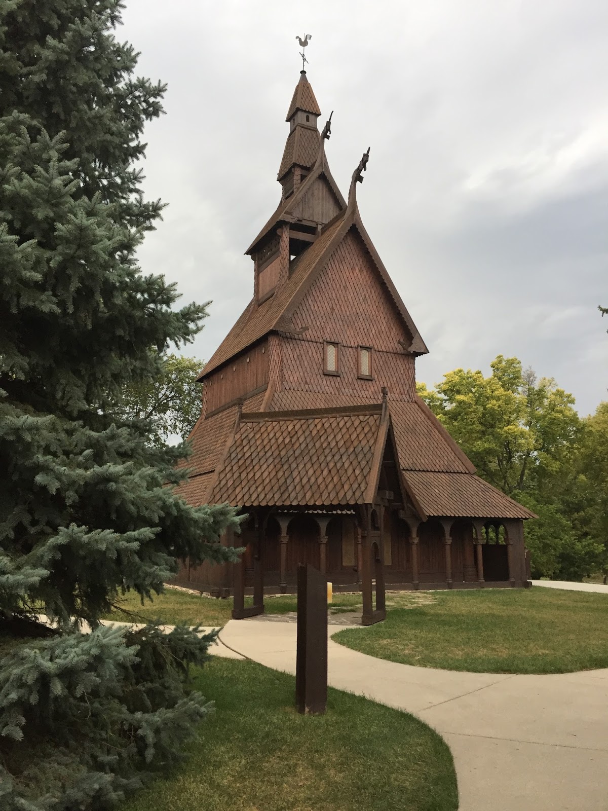
On a similar theme, behind the museum, a different person was inspired by the stave churches of Norway and decided to recreate one here in America.  This building is made entirely of wood, with many fine carvings.  We got the opportunity to see the inside and get a tour.  We also saw several of these while in Norway.  The link above to my blog post has pictures of some of them.


Inside the church, while on tour, our guide had some historical recreations of weaponry, which I had to have my Norwegian-descent husband try on.


In the lobby, before we left, he posed with some of the locals.


It was a very quick visit to Fargo-Moorhead, and perhaps we will visit again next month when we set out to finish this project.  They had a very nice bridge that would make the perfect location for my pictures and GPS coordinates, however . . . IT WAS RAINING!  Not just raining, but there was a lightning show too.  This put the kibosh on my plan to camp another night.  It was just too windy, wet and frankly dangerous.  Documenting our being on this in-between place in Minnesota would be a video crossing the Red River which transects the two cities.


September 19, 2017    I don't know, sometime after 8 PM
GPS - I don't know . . . it was raining!
Elevation . . . no clue . . . it was raining!


After crossing the bridge, we made our way to Alexandria and found a hotel for the night.  The next morning we acquainted ourselves with Big Ole, a tourist attraction just outside the Kensington Runestone Museum.  This is an artifact that was unearthed in 1898, which if authentic, would lend proof that Norsemen made it far into the new world long before Columbus did.  The validity of the claim is disputed.  After you visit the museum, you can make up your own mind about it.


With museum visiting and giant viking watching done, we left Alexandria in search of an apple orchard.  On the way, I spotted this rather beautiful red tail catching some morning rays.  It is an adult with it's rusty red tail, so not trappable, even if I had my trapping gear with me.  In the morning light, the rest of its body was rather washed out light.  It would have been nice to see this bird in hand.  Red tails have such a variety of color, even among standard eastern type.  Soon I will be trapping for this season . . . the cooling fall weather and colors lends excitement to that prospect.


We found the orchard and purchased a lot of apple-based products to take home.


We briefly thought about trying to find the geographic center of the state, however the exact coordinate was disputed by various web sites, I did not have a GPS tracker on me, and some of those coordinates placed the point somewhere in the middle of a lake.  We gave up on that plan and decided to make our way home.  Along the way, we stopped in at New Ulm, where many people of German ancestry settled.  Here they erected a statue at what has become known as the Hermann Heights Monument.  The residents just call him Hermann the German.


Of course, once the Germans got settled in, they had to start making beer.  While in that town Richard wanted to visit the Schell Brewery.  At this time of year, tours are only offered on the weekends, so we could not actually see the beer being made.  We were able to visit their museum and gift shop.  I don't know why I didn't take my own pictures.  The one below is stolen off the Internet.  We were in this room, and saw some of the surrounding grounds, which are very beautiful.  This was the former home of the family that established this brewery.  After purchasing a few souvenirs, and with suggestion from one of the staff, we returned back into New Ulm and found a bar that serves Schell's brews on tap.  I bought Rich a flight of beers, which he enjoyed.  Afterwards, we sought out a German restaurant and had dinner before heading home.


It was a quick whirlwind road trip of three days.  I have some more time next month when we will pick up and add onto this trip.

Until then . . . . . . .

Wednesday, August 23, 2017

The Great American Eclipse 2017

On Sunday, August 20th, Rich and I headed out to go chase the eclipse.

If somehow you have been hiding under a rock somewhere, there was a fabulous eclipse crossing our continent, which was named appropriately "The Great American Eclipse".  However, to see it, to experience it at its most exquisite, you would have to place yourself in the path of totality, a zone spanning about 70 miles wide, stretched across the continent from the West in Oregon to the East in South Carolina.  Minnesota was not in the path, so I have been planning since last November to journey to experience it.

Our eventual experience of the eclipse was not exactly what I would have hoped for, but because so many cameras were focused skyward, many others with very good equipment caught the action.

I would like to thank Colin Ross of CC Megaproductions for giving me permission to use his exceptional recording.  He produced it with appropriate music, and without too much crowd noise.  It is a good representation of what happened . . . if you didn't have too many thick clouds in the way.


We left on Sunday and journeyed to Lincoln, Nebraska, which would be our "home" base for our time in Nebraska.  Arriving late and getting settled into our hotel, we then walked across the street and picked up some greasy Sonic dinner.  Not the best thing to eat when you need to get to sleep for an early start, but it was quick, and it was right there.

All this time, I had been watching the weather and trying to decide in what direction we would drive in the morning.  I wanted to be out the door and on the road by 6 am.  Originally, I had planned to go directly South, very near to Beatrice but not directly in that town.  There was a very large party planned at the Homestead National Park.  I am somewhat adverse to being in large crowds, thus I would not be going to that party.  Also, the weather in that direction didn't look good.  For that matter, the weather in all directions didn't look good.


(Click Map for more detailed image)

One of the local television stations had a pretty good weather report.  There was a narrow band of potential clear-ish skies just South and East of Grand Island.  The weather program I was following at NOAA seemed to agree.  Guaranteed clear skies could not be found unless you were willing to drive an additional 5 hours or more into Western Nebraska or Wyoming.  I was not willing to do that.  We would take our chances.  Google Maps found a quaint little town named McCool Junction (a very cool sounding name) that had a nice park.  When we arrived at about 7:30, there was only two other cars.  We staked out a claim, and I set up my telescope.  As you can see, it was fairly sunny in the morning.  Oh, and added bonus . . . bathrooms!
  

Hindsight is a wonderful thing.  I don't know why I didn't think to acquire an adapter to take pictures with my iPhone.  I guess I figured since I was able to just hold up my cell phone and take a picture, why did I need an adapter.  I probably would have had better pictures.  Without the urgency of the limited time during totality, at my leisure I could take many pictures and discard those I did not like.  Here is the full face of the sun, pre-eclipse.  You can even see sun spots.  As more people came to join us at the park, several ventured over and asked to take a peek.  I also gave out some of the extra eye protection glasses I had.


Richard was the GoPro guy.  We set up our older GoPro on a white surface to capture any shadow bands (we were unsuccessful as it is hard to capture them when you have no sun just before and after totality). He wore the newer one, but then opted to set it up on a fence pointed skyward.  The clouds seemed to have gotten their thickest leading up to totality, and after.  The morning was clear enough, and within an hour after the event it was clear.  Just damn bad luck!!


What I did clearly document was the temperature drop.  Just before C1 (first contact of the moon over the sun) our temperature was 95 degrees.


As the moon traversed across the sun, it began to get cooler.  It is amazing that even with 3/4ths of the sun obscured it visually looks just as bright.  The odd light effects only come into play at the last sliver of light.

You can see below my less-than-expert pictures as the eclipse progressed.  I do find it somewhat artistic to see my own reflection in the lens.


A fellow eclipse watcher, Barry of Wichita, Kansas, a retired science teacher, had brought his spotting scopes, and was using them to project the image of the sun onto a white surface.  He was one of the many people we met and chatted with leading up to the eclipse.  I think this was one of the best features of the location we chose.  It did not get overly crowded, and people were happy to chat with each other.  We met several travelers from Minnesota.  Some of the grounds crew tasked with keeping the ball field mowed were out working that morning.  They came over and said hello and indicated no problem with all of us setting up our equipment and lawn chairs.  They knew very quickly after the event, we would all be gone.


As you can see, getting closer to the point of totality, the images are all getting fuzzy.  It's the clouds!


Richard took this picture with his camera just prior to totality.


I got this image through the telescope.  We did see a pair of hawks lazily soaring together just prior to C2 (totality).  I imagine they were about to be very surprised when the sky would get very dark.  I didn't watch them to see what they would do, as I was distracted with my telescope and all going on around us.  I did see with my own eyes the effect of Bailey's Beads, the last rays of light shining through the craters and valleys on the edge of the moon, like so many shiny pearls on a string.  This I simply enjoyed with my own eyes, knowing I would not capture the effect with my camera.


The temperature during totality.  Notice how dark it is.


I asked a fellow watcher to take our picture during totality.  I think it flashed, as it doesn't look that dark.  That was the most spectacular feature of the eclipse.  Right up until the moment the moon fully occludes the sun, and the deepest shadow crosses over, it just looks like dusk.  Then suddenly, even with obscuring clouds, it is like full night.  Someone at our location shot off fireworks.  You also get the effect of a setting sun at all horizons, and 360 degree sunset.  I did attempt to take a video of that, but must have fumbled the record button, for upon review later, I only see the video after I told it to stop.  I'll not post that as it is very un-exciting to see.


It truly is coldest just after "dawn".  77 was the lowest temperature I recorded.  That was an 18 degree drop within one hour.


During the distraction of totality, and the cloud cover, I managed to lose the sun in my viewing window.  At this point so high in the sky it moves very quickly out of the field of view.  It took awhile for me to find it again, as I did not have strong shadows to guide me (for sun viewing, you can use the shadow of your telescope to orient, as I did not have any solar filters for my spotting scope.)


As the sun returned, the temperature jumped up quickly.


My last view of the event.  By this time, most of the people in the park had packed up and headed out.  Rich and I were in no hurry, and knew the roads would be packed with cars, so we just sat back and enjoyed the sunny park.  Oh, yeah, SUNNY!  The sun came out afterwards.  Of course!


When we did finally decide to leave we opted to skip I80 back to Lincoln, and instead took backroads following our map.  It was a nice drive back to our hotel.  After a shower to get all the sun screen and sweat off, I searched out and found a nice restaurant for us to enjoy an eclipse evening dinner.


We found a place called FireWorks, where you could have tasty wood-fired food.  It was a great ending to a fabulous day.


The next morning we planned to begin to head home, stopping off to visit my sister and brother-in-law at their new home in Marion, Iowa.  Not wanting to come empty-handed, I stopped by a cute bakery I discovered the previous evening when I was researching places to eat dinner.  It is very appropriately named, as it is below ground (see the cars in the reflection) and you have to go down some stairs to get to the front door.  It really was a "rabbit hole".  What was offered inside was an assortment of tasty treats, of which I brought a box full for my family.


It was a great little vacation.  I do so wish we hadn't found all the clouds, but I'm still happy we got the chance to experience life under the moon's shadow.